Ponds a special opportunity for proposed Gentry park
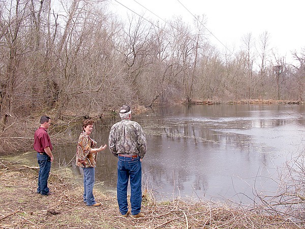
Arkansas Game and Fish Commission region 1 Stream Team coordinator David Evans, right, looks over a pond as Gentry Chamber of Commerce executive director Bev Saunders asks a question while touring the site of a proposed park near Gentry on Feb. 17. Also shown is Gentry Mayor Kevin Johnston.
Wednesday, February 23, 2011
GENTRY — Walking the 10-acre site of a proposed park, a state official marveled at the opportunity the city has to create something special.
“This is beautiful,” said David Evans as he gazed over a series of ponds that are the central features of the land. Evans, of Harrison, the regional Stream Team coordinator for the Arkansas Game and Fish Commission, walked the property at the request of Gentry Chamber of Commerce executive director Bev Saunders.
He and Saunders toured the tract Thursday, along with city council member Janice Arnold and Mayor Kevin Johnston.
After discussing the project over lunch, where they were joined by city council member Janie Parks, Saunders and Johnston decided to re-evaluate the current plan to incorporate Evans’ suggestions.
Addressing the question of cost, Evans suggested that - if done correctly - cost may be low. His advice is to do little to the site, other than minimal trails, signs, maybe a fishing pier in one of the ponds, and controlled fires to clear the land. Development could be done in stages spread out over years, with specific jobs adopted by groups from the community.
On Monday, Saunders said that Evans is working to identify a couple of funding sources.
The ponds, fed by a city-owned spring across Sleepy Hollow Road, are on land west of Arkansas Highway 59 where it crosses Flint Creek. Decades ago - maybe in the 1950s, Johnston said - the city built a pump system to draw water from the creek for use as thecity water supply.
The ponds had previously been referred to as old beaver ponds; however, examination showed that the ponds are man-made. The beaver dams plug holes where the spring-fed creek breached the dams. Fresh beaver-chewed sticks, along with a series of muddy spots where beaver slide into the water, indicate frequent use.
Saunders asked Evans if dredging the ponds to make them deeper is a good idea. Arnold had suggested the ponds could be fishing ponds eligible for stocking by the Arkansas Game and Fish Commission. A fisheries biologist told the city the ponds need to be at least eight feet deep.
“Be careful,” Evans said. “Ponds have a clay bottom that holds in the water. If you punch a hole in that, all your water will drain out.” He noted that just because the ponds aren’t extremely deep doesn't mean they can’t serve as fishing ponds.
He suggested that determining the water depth, as well as depth of the mud/silt bottom, is fairly simple. A boat and long pole is all that’s needed to probe the depths.
On Saturday, Saunders used a flat-bottomed boat and an 8-foot-long piece of PVC pipe to determine the depth. One pond holds 3 feet of water, while the other holds 4 feet. The mud in both averages 2 feet deep. In the larger of the ponds, the maximum depth of the mud is more than 3 feet.
During Thursday’s tour, Saunders and Johnston asked about the best way to clear brush.
Evans said clearing the site to create a setting typically seen in a city park would be a mistake. He suggested setting fireto clear the land by utilizing a natural method. The fire will burn underbrush as well as leaf litter, causing wildflowers and other plants to flourish.
“Doing as little as possible here will be best,” Evans said multiple times.
Standing in the Flint Creek flood plain, Evans explained how creek formed terraces rise like steps above the creek, allowing floods to spread out and slow down. He noted that the creek has excellent bank structure not marked by erosion. Trying to do too much could adversely affect the balance of the system.
“Everything along the creek creates friction and slows the water down,” Evans explained. “Man has worked to change thesystems, worked to get the water out as fast as possible - removed that friction.” That causes erosion and worse flooding for people downstream.
Saunders and Johnston discussed trails that could cross the site, yet have little impact. Educational signs could be erected explaining the natural systems at work - such as the beaver dams and how they manage the ponds, and how the terraces and plants along the creek manage floods - as well as identifying the plants on the land.
A rusting car partially buried by gravel could be left in place to show how humans have historically used creeks as dumping grounds and how nature deals with that abuse.
News, Pages 1 on 02/23/2011