
DECATUR -- It will be a long time before northwest Arkansas and eastern Oklahoma recover from one of the worst winter storms in more than 35 years.
What began as an unusually warm Christmas Day (in the 60s and 70s in some places) quickly turned into chaos when the mid section of the country was hit with what would be known by the National Weather Service as Winter Storm Goliath.
Early on the morning of Dec. 26, the region experienced light rain showers that quickly turned violent as super cell thunderstorms began to build in southeastern Texas near the Dallas-Fort Worth metroplex, prompting the National Weather Service to issue a tornado watch for much of eastern Texas and southeast Oklahoma. At the time, northwest Arkansas and northeast Oklahoma were not included in this watch. By sunset, that would quickly change.
Late in the evening, a tornado hit Garland, Texas, killing at least 11 people. Those fatalities were travelers on their way home from Christmas gatherings. Tornadoes continued from south of the Dallas area, moving north into southeast Oklahoma.
With the tornado threat confined to areas south of northwest Arkansas, residents of Gentry, Decatur, Gravette, Siloam Springs and Hiwasse were caught completely off guard as a series of super cell thunderstorms with radar-indicated high-level rotation rolled through the area. Suddenly, the tornado sirens were going off, sending area residents scrambling for shelter and the National Weather Service dealing with tornadoes in areas it never expected. Even southwestern Missouri residents were caught off guard by tornadic thunderstorms moving through their area late in the evening.
As the tornado threat diminished in northwest Arkansas and eastern Oklahoma, heavy rain began to fall. For this area, the rains reached epic proportions as rates of one to two inches per hour fell, prompting flash flood warnings for the entire area.
By Sunday, Dec. 27, nearly 10 inches had fallen in some areas, with more on the way. Benton County Road Department closed so many roads by late afternoon that the department ran out of barricades and had to use caution tape to block the flooded roads.
State Highway 264 near the entrance to Northwest Arkansas Regional Airport was closed as flood waters inundated Healing Springs and Cave Springs, causing washouts of driveways and county roads. Big trees that once stood on solid ground along the banks of smaller creeks and streams were toppled by the sudden flash flooding eroding the soil from beneath their roots.
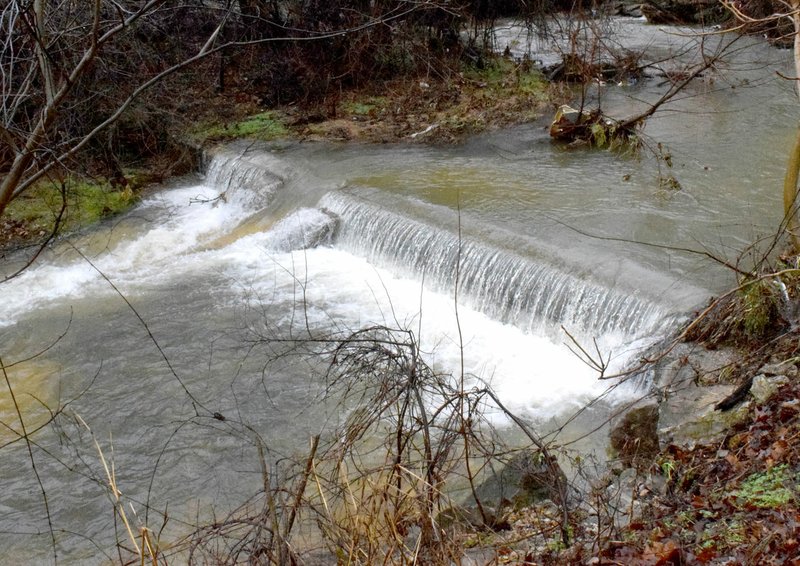
At Decatur's Crystal Lake, water levels rose so high that the spillway poured into Wolf Creek, creating a series of rapids before hitting the waterfall below the dam. Debris, from leaves and small branches to large logs, was scattered up and down the banks of the lake. As the lake levels began to drop early Tuesday, Dec. 29, it left behind signs of just how high the lake had risen during the storm. Sticks, pine needles and eroded soil left an indelible mark half way up the boat dock ramp. The portable outhouse that had once stood facing the lake was now turned 90 degrees and had floated about five feet away from its original spot.
What was once a beautiful sparkling lake had turned brown from erosion that destroyed rich farm land. It could take months for Crystal Lake to return to its former beauty.
One death due to the storm was reported in Pope County when a Dove man was caught in rapidly rising water and drowned. Fortunately, there were no fatalities in northwest Arkansas due to the storm.
On Dec. 31, only hours from the new year, the National Weather Service extended flood warnings for all the counties in northwest Arkansas and eastern Oklahoma which are still experiencing flood waters that are slow to recede. Most of the warnings continued until 12:45 on Jan. 1, almost a week after the storm hit the area. It was likely the area would continue to carry flood warnings for several days.
It may take weeks or even months for the region to recover from the devastating effects of what was called Winter Storm Goliath. With the new year upon us, who knows what kind of weather the region will experience through the remainder of the winter season. But one thing is certain, residents of northwest Arkansas and eastern Oklahoma will have a greater respect for the weather and be better prepared for anything that nature may throw at them in the future.
General News on 01/06/2016