Pilot, reporter view Decatur from the skies

Westside Eagle Observer/MIKE ECKELS

Decatur, Arkansas, population 1,699, as seen from a Cessna 172 piloted by flight instructor Lance Dixon July 28.
Westside Eagle Observer/MIKE ECKELS Decatur, Arkansas, population 1,699, as seen from a Cessna 172 piloted by flight instructor Lance Dixon July 28.

DECATUR -- It is easy to take for granted the beauty of a town when you drive from home to work and back again on the same roads every day. People may perceive their town as dull and boring. But looking down upon that same little town from above makes that same little town anything but mundane.

Flight instructor Lance Dixon took a local photographer up for a view of the city of Decatur July 28 to document the changes to the little extreme Northwest Arkansas town that occurred over the last several years.

Taking off from runway 31 at Decatur's Crystal Lake Airport, Dixon headed west for about two miles before turning south toward the downtown area of Decatur. The Cessna 172 Skyhawk, a four-seat single-engine high-wing aircraft was the perfect platform for taking photos of the terrain below.

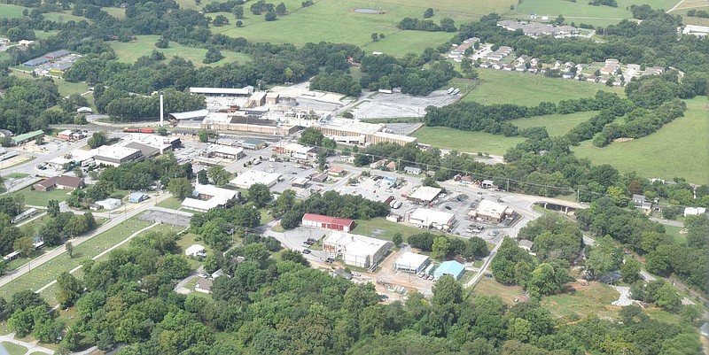
The flight proceeded south along the western border of Decatur, taking in all the sights of the town from the old Simmons plant to city hall which is perched majestically above the downtown area. Continuing south past the TNT complex and the hatchery, the Simmons Prepared Foods poultry processing facility came into view.

From the air, the size of one of the biggest poultry processing plants can be seen spreading out over the top of the hill next to Y-City Road.

From Simmons, the flight headed east for a short time before turning to the north. Soon, the Decatur middle and high schools came into view. The plane circled the school and sports complex at which, by chance, the high school football team was finishing up its Tuesday morning light practice session. The photographer caught the ants on the practice field below going through a drill.

"So this is what sports action looks like from a Blimp's point of view," the photographer thought as the flight began its second westward leg.

After one last look at the heart of Decatur, the pilot turned back toward Crystal Lake Airport. Turning final to runway 13, the 3,861-foot asphalt landing strip with Crystal Lake and the airport hangars looming on the end marked a picture-perfect end to the 15-minute photo mission.

Westside Eagle Observer/MIKE ECKELS

An aerial view of Decatur, Arkansas looking east. Some of the local landmarks include the old Simmons processing plant (lower center), Decatur City Hall (left) and downtown Decatur (center).This view of Decatur was taken by a local photographer on a July 28 overflight in a Cessna 172 piloted by flight instructor Lance Dixon.
Westside Eagle Observer/MIKE ECKELS An aerial view of Decatur, Arkansas looking east. Some of the local landmarks include the old Simmons processing plant (lower center), Decatur City Hall (left) and downtown Decatur (center).This view of Decatur was taken by a local photographer on a July 28 overflight in a Cessna 172 piloted by flight instructor Lance Dixon.
Westside Eagle Observer/MIKE ECKELS

An aerial view of Decatur looking down Roller Avenue to the west shows the heart of the town. Flight instructor Lance Dixon, piloting a Cessna 172 Skyhawk, was on a short photo mission July 28 with a local photographer.
Westside Eagle Observer/MIKE ECKELS An aerial view of Decatur looking down Roller Avenue to the west shows the heart of the town. Flight instructor Lance Dixon, piloting a Cessna 172 Skyhawk, was on a short photo mission July 28 with a local photographer.
Westside Eagle Observer/MIKE ECKELS

An aerial view of the Decatur High School sports complex taken July 28  shows Bulldog Stadium (top  center), practice field (right) and Peterson Gym (bottom right). The agriculture building (lower left)  and animal barn (left) are the other two structures in the photograph.
Westside Eagle Observer/MIKE ECKELS An aerial view of the Decatur High School sports complex taken July 28 shows Bulldog Stadium (top center), practice field (right) and Peterson Gym (bottom right). The agriculture building (lower left) and animal barn (left) are the other two structures in the photograph.
Westside Eagle Observer/MIKE ECKELS

The Simmons poultry processing plant located between Decatur and Gentry was captured from the air July 28 during a recent photo reconnaissance mission over Decatur. This Simmons plant is one of the largest poultry processing facilities of its kind in the world.
Westside Eagle Observer/MIKE ECKELS The Simmons poultry processing plant located between Decatur and Gentry was captured from the air July 28 during a recent photo reconnaissance mission over Decatur. This Simmons plant is one of the largest poultry processing facilities of its kind in the world.