Deluge of rain inundates area with water

Westside Eagle Observer/MIKE ECKELS
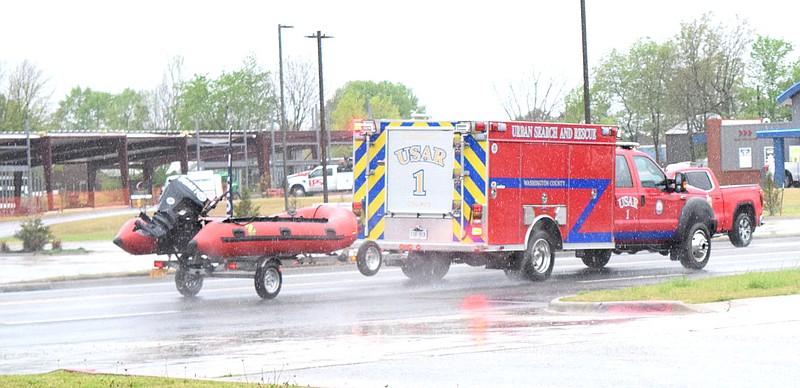
An Urban Search and Rescue truck towing a Zodiac boat races down U.S. Highway 412 in Tontitown April 28 on its way to a swift water rescue somewhere in the Washington County area. Around three inches of rain fell in a 12 hour period, prompting the National Weather Service to issue Flash Flood Warning leading to the need for deployment of these specialized units.
Westside Eagle Observer/MIKE ECKELS An Urban Search and Rescue truck towing a Zodiac boat races down U.S. Highway 412 in Tontitown April 28 on its way to a swift water rescue somewhere in the Washington County area. Around three inches of rain fell in a 12 hour period, prompting the National Weather Service to issue Flash Flood Warning leading to the need for deployment of these specialized units.

DECATUR -- KABOOM, KABOOM, KABOOM! The constant sound of thunder was heard all through the area as several lines of severe thunderstorms slammed Northwest Arkansas and Eastern Oklahoma on April 28. Many area residents were shaken out of their slumber by the almost constant lightning and thunder barrage throughout the early morning hours.

However, as the day progressed, the situation went downhill as a constant deluge of heavy rain continued, causing area streams, creeks and lakes to flow over their banks. At around 10 a.m. the Illinois River was over its banks near the bridges on U.S. Highway 412 just west of Siloam Springs, causing the flood plain to fill rapidly.

As the morning progressed, several swift water rescue units were called out in Washington and Benton Counties to aid stranded motorists who failed to heed warnings and drove onto flooded roads.

Then, about mid-afternoon, the rain tapered off a bit with just light rain from time to time. This would not last long, as thunderstorms began to build to severe limits in southwest Oklahoma, around McAllister, moving northeast, and by 9 p.m. the second round of heavy rain with lightning moved into the area, causing additional flooding in Benton County.

The national weather service estimated that between two to five inches of rain fell between about 6 a.m. and 11:45 p.m. on Wednesday. But the worst was far from over for Northwest Arkansas.

At around 10:45 p.m. the National Weather Service issued yet another Flash Food Warning for Washington Counties and several counties to the south and east of Washington County.

While Benton County was spared the additional one to three inches Washington, Adair, Madison and Carroll Counties picked up most of the early morning on Thursday, it was not out of the woods just yet. Areas around Gentry, Decatur and Siloam Springs picked up an additional two inches, causing more flooding.

By Thursday morning, most of the heavy rain moved into southern Arkansas, leaving the area with cloudy skies and cooler temperatures. When the sun went down, area residents were treated with an array of pinks, oranges, and purple colors, marking the end of the two-day event.

Westside Eagle Observer/MIKE ECKELS
Water flows over the spillway next to the overflow pond at Crystal Lake April 28 after over three inches of rain from heavy thunderstorms blanketed Northwest Arkansas, causing major flooding along area lakes and rivers. Crystal Lake overran its banks briefly before receding back below major flood stage.
Westside Eagle Observer/MIKE ECKELS Water flows over the spillway next to the overflow pond at Crystal Lake April 28 after over three inches of rain from heavy thunderstorms blanketed Northwest Arkansas, causing major flooding along area lakes and rivers. Crystal Lake overran its banks briefly before receding back below major flood stage.
Westside Eagle Observer/MIKE ECKELS
On South Collins Avenue near the turnoff to Arkansas 59 in Gentry, a storm drain is inundated with water after a series of very heavy thunderstorms dropped over three inches of rain in a short period, causing water to back up into the field and on the street itself April 28. Scenes like this played out over much of Northwest Arkansas and Eastern Oklahoma.
Westside Eagle Observer/MIKE ECKELS On South Collins Avenue near the turnoff to Arkansas 59 in Gentry, a storm drain is inundated with water after a series of very heavy thunderstorms dropped over three inches of rain in a short period, causing water to back up into the field and on the street itself April 28. Scenes like this played out over much of Northwest Arkansas and Eastern Oklahoma.
Westside Eagle Observer/MIKE ECKELS
As floodwater from the Illinois River (background) begins to take over farmland on the floodplains between the U.S. 412 bridges east of Siloam Springs April 28, a herd of cattle found refuge and greener pastures on higher ground. A series of very heavy thunderstorms dropped over three inches of rain in less than 12 hours causing major flooding.
Westside Eagle Observer/MIKE ECKELS As floodwater from the Illinois River (background) begins to take over farmland on the floodplains between the U.S. 412 bridges east of Siloam Springs April 28, a herd of cattle found refuge and greener pastures on higher ground. A series of very heavy thunderstorms dropped over three inches of rain in less than 12 hours causing major flooding.
Westside Eagle Observer/MIKE ECKELS
A beautiful sunset at Bulldog Stadium in Decatur greets area residents with an array of pinks, oranges and purple colors after two days of heavy thunderstorms dumped over six inches of rain in the area.
Westside Eagle Observer/MIKE ECKELS A beautiful sunset at Bulldog Stadium in Decatur greets area residents with an array of pinks, oranges and purple colors after two days of heavy thunderstorms dumped over six inches of rain in the area.